Africa, the world’s second-largest continent, may not always remain a single landmass. Recent scientific research indicates that the continent is slowly splitting apart along the East African Rift, a massive geological fracture that stretches over thousands of kilometers from the Afar Triangle in Ethiopia down to Mozambique. Scientists warn that, over millions of years, this rift could eventually widen enough to form a new ocean, effectively dividing Africa into two separate continents. This phenomenon has fascinated geologists, climate scientists, and the public alike, and recent satellite imagery, field data, and animated videos provide compelling evidence of this slow but dramatic geological process.
Understanding the East African Rift
The East African Rift (EAR) is a tectonic plate boundary where the African Plate is in the process of splitting into two smaller plates: the Nubian Plate to the west and the Somali Plate to the east. Unlike earthquakes or volcanic eruptions, which occur suddenly, continental rifting happens over millions of years, with the land slowly stretching, cracking, and sinking.
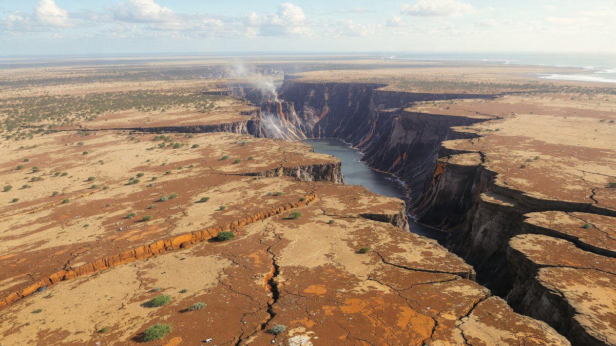
The rift is associated with significant volcanic activity, deep valleys, and long, narrow lakes that mark its boundaries. Iconic features such as Lake Tanganyika, Lake Malawi, and the Danakil Depression exist because of the rift’s ongoing geological activity. In some places, fissures and cracks can be seen extending for several meters, a clear indication of the tectonic forces at work.
Evidence of Continental Splitting
Scientists have collected multiple lines of evidence to confirm that Africa is indeed slowly splitting:

- Satellite Imagery and GPS Measurements: Modern satellites can measure ground movement with extreme precision. GPS data shows that the Somali Plate is moving eastward relative to the Nubian Plate at a rate of roughly 6–7 millimeters per year. While this may seem slow, over millions of years, this movement is enough to create a new ocean.
- Geological Formations: Field studies reveal active faults, volcanic cones, and magma intrusions that stretch across the rift valley. These formations provide tangible proof that tectonic forces are actively shaping the land. In some regions, fissures have widened into trenches dozens of meters deep, indicating the beginning stages of continental separation.
- Seismic Activity: Earthquakes frequently occur along the rift, though most are relatively small. These tremors are a sign that the crust is under stress and slowly fracturing, a natural part of the rifting process.
- Volcanic Activity: The East African Rift is home to several active volcanoes, including Mount Nyiragongo in the Democratic Republic of Congo and Mount Erta Ale in Ethiopia. Volcanic eruptions contribute to crustal stretching and the creation of new landforms, accelerating the rifting process.
How a New Ocean Could Form
The splitting of Africa is expected to continue for millions of years. As the rift widens, magma from the Earth’s mantle rises to fill the gap, creating new crust. Eventually, the rift could become deep and wide enough for seawater to enter, forming a narrow ocean basin. Over time, this new ocean would expand, effectively splitting Africa into eastern and western halves.
Experts predict that the Horn of Africa, including countries like Somalia, Ethiopia, and Kenya, could become part of this new eastern landmass. Meanwhile, the rest of Africa would remain on the western side, separated by a narrow body of water that could eventually widen into a significant ocean. While this process is slow, understanding it helps scientists predict long-term geological changes and prepare for potential environmental consequences.
The Afar Triangle: Africa’s Tectonic “Hotspot”
The Afar Triangle in Ethiopia is considered the epicenter of Africa’s tectonic activity. It is a unique geological region where three tectonic plates—the Nubian, Somali, and Arabian Plates—meet, forming a triple junction. Here, the crust is thinning at a faster rate than in most other rift regions, creating visible cracks, volcanic activity, and subsidence.
Scientists have used high-resolution videos and satellite imagery to monitor changes in the Afar region over recent decades. Footage shows deep fissures opening, magma flows rising, and large land sections gradually sinking. These visual records provide an unprecedented view of the slow but powerful forces that could one day split Africa in two.

Geological Timescale
It is important to understand that the process of forming a new ocean is extremely slow by human standards. While GPS measurements show movement of only millimeters per year, over tens of millions of years, these small shifts accumulate into enormous geographical changes.
Estimates suggest that it could take anywhere from 5 to 10 million years for the rift to widen enough for a new ocean to form. This long timescale means that, while the phenomenon is fascinating and scientifically significant, it will not affect human populations in the immediate future. However, the study of rifting provides insights into how continents break apart and how new oceans and ecosystems are formed.
Impacts on the Environment and Ecosystems
Even though the formation of a new ocean is millions of years away, the rifting process already affects local ecosystems. The creation of deep valleys and lakes changes water flow, affecting aquatic species. Volcanic activity enriches soil, promoting unique vegetation patterns that support wildlife.
Some animals have adapted to the shifting landscape, while others may face challenges due to habitat changes. Birds, fish, and mammals in the rift valley are already impacted by seismic activity and periodic flooding. Understanding these changes helps conservationists plan for the long-term preservation of species in the region.

The Role of Videos and Visualization in Science
One of the most compelling ways scientists communicate the ongoing split is through videos and animations. Using satellite imagery, drone footage, and computer simulations, researchers have created visual representations of how the continent is moving.
These videos allow both scientists and the public to grasp the magnitude of continental drift in real-time. Watching cracks slowly widen, magma rising, and land sections sinking makes the abstract concept of tectonic movement more tangible. Videos also demonstrate how the rift might evolve into a new ocean over millions of years, helping to visualize a process that would otherwise be impossible to witness in a single human lifetime.
Scientific Collaboration and Research
The study of Africa’s rifting involves geologists, seismologists, volcanologists, and satellite specialists from around the world. Collaborative efforts have led to detailed maps, 3D models, and predictive simulations of the rift’s evolution. International research stations in Ethiopia, Kenya, and Djibouti monitor seismic activity, volcanic eruptions, and ground movement daily.
This collaborative approach ensures accurate data collection, peer-reviewed findings, and global awareness of the ongoing geological transformation. It also supports broader studies of tectonic activity on other continents, helping scientists understand how Earth’s landmasses change over time.

Historical Context: Continents in Motion
Africa’s slow split is part of a larger story of continental drift. Earth’s continents have never been static. Over hundreds of millions of years, tectonic plates have collided, formed supercontinents, and drifted apart. The most famous supercontinent, Pangaea, existed around 335 million years ago before breaking apart to form the continents we know today.
By studying the East African Rift, scientists gain insight into the mechanics of continental breakup and ocean formation. Similar rift systems exist elsewhere, such as the Mid-Atlantic Ridge, where the Atlantic Ocean is gradually widening. These comparisons help researchers predict the long-term evolution of Earth’s surface.
Public Interest and Educational Value
The idea that Africa could split and a new ocean might form has captured the imagination of the public, educators, and media outlets. Videos and satellite visualizations serve as powerful educational tools, helping students and enthusiasts understand the forces shaping our planet.
Understanding the rift also underscores the dynamic nature of Earth, reminding us that the landscapes we see today are temporary in geological terms. It inspires curiosity about the past, present, and future of continents, oceans, and the life they support.

Conclusion
Africa’s slow split along the East African Rift is a vivid example of the planet’s dynamic geology in action. Supported by GPS measurements, seismic monitoring, volcanic observations, and compelling video evidence, scientists have confirmed that the continent is gradually dividing into two plates. Over millions of years, this process could result in the formation of a new ocean, fundamentally altering the geography of Africa and influencing ecosystems and climates across the region.
While the timescale of this transformation is vast, the evidence provides valuable insights into tectonic forces, continental drift, and the evolution of Earth’s surface. Videos and satellite imagery help make these abstract processes tangible, allowing both scientists and the public to appreciate the power of geology at work.
By studying the East African Rift, researchers not only observe a future ocean in the making but also deepen our understanding of Earth’s history, the interconnectedness of ecosystems, and the ever-changing nature of our planet. The splitting of Africa is a slow-motion natural event, a reminder that the Earth is alive and continuously reshaping itself, and a scientific story that will continue to unfold for millions of years.
Leave A Comment